Weekend Brings Long-Awaited Relief From Smoke
The arrival of a moisture-laden cold front on Sunday will do wonders for our air quality.
CHARLOTTE, N.C. — The smoke’s reign of terror will finally come to an end this weekend.
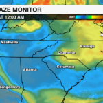
Haze from large wildfires in Canada has dominated the East Coast’s skies over much of the past week, creating health hazards and travel headaches alike, while turning iconic skylines into scenes fit for a post-apocalyptic movie. At one point on Wednesday, New York’s air quality was among the worst in the world. Areas in eastern Pennsylvania set all-time marks for smoke pollution. Back home, Charlotte recorded its first Code Red air quality alert in nearly a decade.
New York City looks like Mars right now. #wildfire #smoke #NYC #Mars pic.twitter.com/S8sckTC8ev
— Kaitlin Wright (@wxkaitlin) June 7, 2023
Fortunately for us, the cliché “all good things must come to an end” seems to apply to bad things, as well. At least… in this case, it does.
So, what’s finally bringing us better fortunes?
It’s a combination of wind and rain.
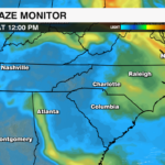
A powerful area of high pressure will build into the Carolinas this weekend and move eastward, shifting prevailing winds in the Carolinas out of the southwest. Since virtually all of the prolific smoke-producing fires are located to our north, this wind profile will push some of the haze out of our area.

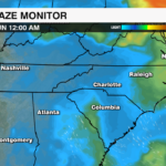
Next, the stalled-out chain of systems located to our south and west will finally get the lead out of its pockets and race across the Carolinas by Sunday evening. Scattered showers and storms will have a cleansing effect on our layer of the atmosphere, taking whatever smoke is left and washing it away with the rain. Rain chances will last into Monday; the more rain we get, the more air quality will improve. Right now, most communities in the WCCB Charlotte viewing area should receive between a half-inch and an inch through the start of the workweek, which is more than enough to provide us with a deep clean.


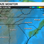
Arguably, the most important part of this equation is what happens after the rain. While winds will briefly shift back out of a more northerly direction, they won’t last long enough to re-establish a connection with Canadian wildfire smoke. As incoming air returns out of the south and west, any stubborn haze will be pushed out again.
THE BOTTOMLINE: Mother Nature will finally give us a helping hand by the end of the weekend, but as long as record-setting wildfires are burning in eastern Canada, smoke will always be a northerly shift in wind direction away. Fortunately, southerly winds and rain chances are in the forecast for much of next week, which should keep the haze at bay… for now.


