Elsa Expected to Become a Hurricane Before Landfall
Hurricane Warnings in Place for portions of Florida's West Coast
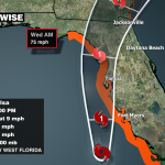
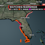

Hurricane Warning is now in effect for portions of Florida west coast from Egmont Key to Steinhatchee River.

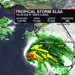
As of Tuesday evening, all the wind, rain, and surge are on the east side – this is not good news for the west coast of Florida. The intensity forecast has also slightly changed. Maximum sustained winds are now at 70 mph with a Category 1 hurricane likely at landfall (74 mph+). Strong tropical storm or “weak” category 1 hurricane – impacts do not change for Florida or for the WCCB area.

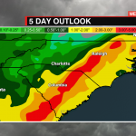
Impacts for the WCCB Charlotte area IF there is no dramatic shift west:
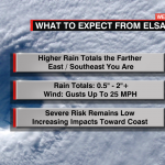
RAIN:
- 0.5” North of I-85
- 1-3”+ South of I-85
** The farther east/southeast you are, the higher the rain total. - EAST of I-95: Isolated tornadoes + 2-4 inches of rain
WIND:
- Gusts up to 25 mph possible.
TIMING:
- Overnight Wednesday through Thursday.

For now, plan for a breezy Wednesday night with scattered showers and a few storms that could bring intense downpours through Thursday. Right now, the heaviest rain across the Carolinas will track through the center and eastern portions of the state.
Make sure you have multiple ways to receive alerts should they be issued and download our WCCB Weather App to get the latest on Tropical Storm Elsa.