Warming trend moves in
By the time we get into Wednesday, it’s going to feel like we have hit spring. We may wake up to a little patchy fog, but once that burns off, temperatures take off climbing all the way into the mid-70s.

By the time we get into Wednesday, it’s going to feel like we have hit spring. We may wake up to a little patchy fog, but once that burns off, temperatures take off climbing all the way into the mid-70s.
Tuesday will start off under a blanket of clouds, but don’t worry the sun will start to peek through by the afternoon as highs rebound to around 60°, bringing a touch of spring warmth back to the region.

Did you know that about 10% of thunderstorms in the U.S. each year are classified as severe? That means they can pack wind gusts of 58 mph or higher, produce hail the size of a golf ball or bigger, or even spawn tornadoes. These storms are serious threats to both life and property, so it’s crucial to be ready.
We’ll start things off with a bit of leftover cloud cover and some patchy fog, but by late morning into the afternoon, sunshine takes over. Winds stay light and temperatures climb into the upper 60s, making it one of those perfect days for outdoor activities. By evening, skies clear out and temperatures dip into the lower 40s.

Friday brings a noticeable shift as we transition away from the rain and toward a much nicer weekend.
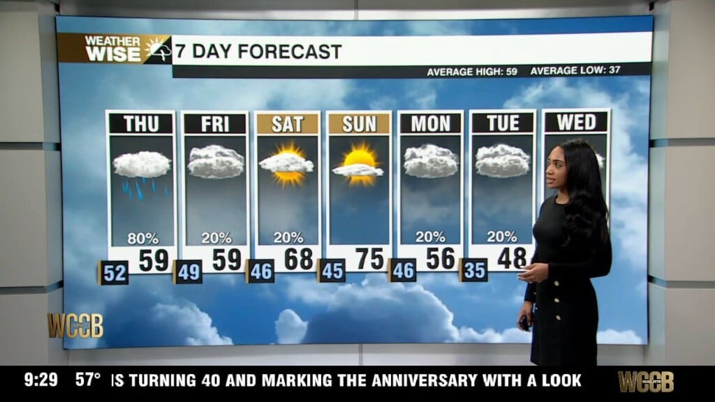
Tomorrow shapes up to be the soggiest day of the week, with rain expected to impact us through the entire day. Rainfall totals will land between a half inch to an inch, which could slow things down during the morning drive. Afternoon temperatures won’t budge much, topping out in the lower 60s, so expect a cool, damp feel through the day.
Wednesday is really about to deliver! Temperatures climb a solid 10 to 15 degrees, landing us right around 60. We’ll juggle clouds and sunshine, but it’s going to be windy. Those gusts could push close to 30 mph. Enjoy the dry, mild weather while you can, because rain makes a comeback on Thursday.
By Tuesday, things start improving. We’ll wake up to a frosty start, but sunshine takes control quickly. With lighter winds and bright skies overhead, temperatures rebound into the upper 40s during the afternoon. It’s still cool, but compared to the morning, it’ll feel much more comfortable.
The weekend kicks off on a soggy note, with rain and a few storms possible early in the day Saturday. As the morning continues stronger activity shifts south, giving us a chance to squeeze in some afternoon sunshine.
That warm southerly wind is making everything feel very spring-like, along with pulling in moisture straight from the Gulf of Mexico. So while we’re enjoying record- warmth, we’re also keeping an eye on rain chances. Friday, starts off unusually warm with morning temperatures in the low 60s along with the possibility of a few showers or even an isolated storm. As we move toward late morning and early afternoon, sunshine should break through, helping temperatures climb near 80 degrees.
 Formerly Twitter